-
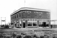 GB 012
 Two-story brick corner building that houses the Hotel Craven, Bank of Hollister, Dr. W. A. Parrett, and the Salmon River Store Co. A man stands beneath a wooden Salmon River Store, Co. sign at right and an automobile (car) is parked on left. A chicken runs across the area in front of the building.
-
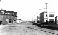 GB 011
 The corner of Broadway and Main Street in Buhl, Idaho. Buhl Bank and Trust on the right , and the Hotel Buhl on left. Other businesses visible include: The Monopole; Buhl Meat Market; Maze Theater
-
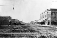
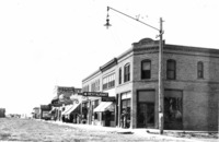 GB 010
 "Gooding;" view of one side of Main Street in Gooding. Businesses and buildings visible include: The Toggery; Light and Power; The McIntosh Drug Store; Byers's Bakery and Café Confectionery; Star Restaurant; Madeline Hotel. A man and woman peer into one of the windows of the corner building.
-
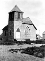 GB 009
 "Presbyterian Church, Gooding, Idaho;" masonry church; other houses or outbuildings in background.
-
 GB 008
 "Filer, Idaho;" view down unpaved Main Street of Filer. Buildings and businesses visible include: lumber store; Strauss Outfitter; Filer Bank
-
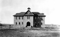 GB 007
 "Hansen School;" a two-story brick school, with bell tower at top. A man stands in the yard at left, and the school is bordered with a wooden fence. A house and outbuildings visible in background.
-
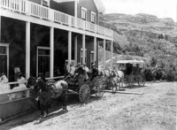 GB 006
 "Stages at Shoshone Falls;" The Shoshone Falls Hotel (also known as Little Dewey House) with several people seated on the porch. A wagon and a covered buggy with horses and passengers are parked alongside the building.
-
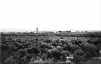 GB 005
 "Hollister in 1912;" wide view of early Hollister across a sage brush plain, showing several buildings.
-
 GB 004
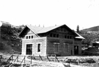
 "Malad Power Plant;" brick power station building on the Malad River, near Hagerman, Idaho. Several outbuildings and equipment are also visible.
-
 GB 003
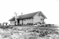
 Railroad station (depot) in Filer, a man stands in front.
-
 GB 002
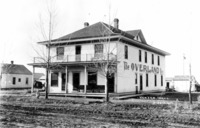
 "Hansen, Idaho;" the Overland Hotel, with a man on the porch and a child in the street. Other buildings in background are visible.
-
 GB 001
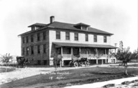
 "Twin Falls Hospital;" large brick building with a wide front porch area; an automobile (car) is parked in front and a buggy and horses are at the side. This building was enlarged from the original building.
-
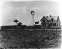 E 017
E 017 "The Home of Dr. Henry, near Gooding, Idaho;" View of a two-story farm house, several outbuildings, and a windmill across a field. A man leads a team of horses at left.
-
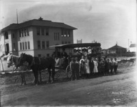 E 016
E 016 "School Days;" children posed on and in front of a school wagon on a street by school in Gooding. Houses are also visible in the background.
-
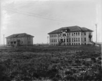 E 015
E 015 "State School for Deaf and Blind. Gooding, Idaho;" Two large stone buildings viewed from across a field. Students and other adults are posed on the steps of the larger buildings, while a group of men with wheelbarrows and other equipment work on the land between the buildings.